Why to book our thru-hiking self guided Lechweg Trail?
✓ A unique multi-cultural hike through the breathtaking alpine landscapes of the westernmost Austrian state of Vorarlberg, Tyrol and Bavaria!
✓ Cozy local accommodations and B&Bs at the end of each day, so you don’t have to carry your sleeping gear!
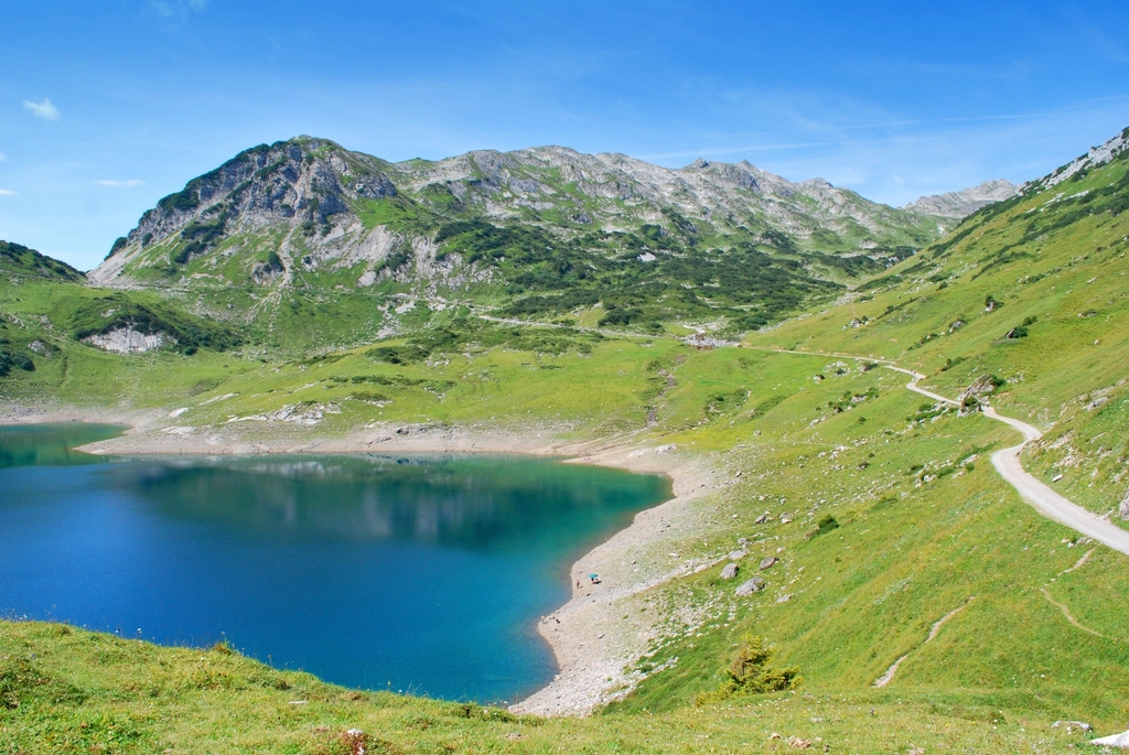
✓ Passing through lakes, canyons, waterfalls, forests, villages and castles.
Program of thru-hiking the Lechweg Trail

125
KM
9
Nights
10
Days
Day 1: Arivale to Lech am Arlberg
Today you will arrive independently to Lech am Arlberg, a mountain village located on the banks of the river Lech in Vorarlberg, the westernmost Austrian state and a great base for travelers exploring the region and hiking the Lechweg Trail.
Meals: NA
Accommodation: Hotel in Lech am Arlberg
Day 2: From Formarinsee to Lech am Arlberg – 16 km
You will start the day with traveling up the valley to Formarinsee (Lake Formarin) where you will start your journey on the Lechweg Trail. The trail starts near Lech River not far from its source. During this hiking day, the trail descends along the wild river of Lech, through the forest and alpin view.
—
Estimated hiking profile:
Difficulty: moderate
Distance: 16 km
Highest point: 1870 m.a.s.l.
Lowest point: 1440 m.a.s.l.
Elevation Gain: 105 m
Elevation Loss: 525 m
—
Transportation: Local transportation to the lake
Meals: Breakfast
Accommodation: Lech am Arlberg
Day 3: From Lech am Arlberg to area of Warth – 11 km
Today’s trail takes you mostly above the river, through alpine views, forests and meadows. You will cross several tributaries of the Lech River such as Walkerbach, Salztobel, Ramstobel and more. Toward this day’s hike, you will cross Lech river and start ascending toward the foothills of Mount Gehrner Berg.
—
Estimated hiking profile:
Difficulty: Easy
Distance: 11 km
Highest point: 1520 m.a.s.l.
Lowest point: 1320 m.a.s.l.
Elevation Gain: 357 m
Elevation Loss: 307 m
—
Meals: Breakfast
Accommodation: Area of Warth
Day 4: From area of Warth to area of Steeg – 15 km
This day’s hike starts below the Austrian-German border at the foothills of Mount Gehrner Berg, the southernmost mountain peak in Germany. On this day you leave Lech River, passing River Krumbach, a tributary of Lech River, crossing Lechleiten, a small alpine village and moving toward Tiefes Tal. The path of next part of today’s trail, descends back to Lech River from where you will walk along the riverbank all the way to the area of Steeg.
—
Estimated hiking profile:
Difficulty: moderate
Distance: 15 km
Highest point: 1570 m.a.s.l.
Lowest point: 1116 m.a.s.l.
Elevation Gain: 172 m
Elevation Loss: 546 m
—
Meals: Breakfast
Accommodation:
Day 5: From area of steeg to area of Bach – 16 km
The 5th day of your journey along the Lechweg Trail starts with easy walking along the valley. Once you arrive at Holzgau you will leave the Lech River and ascend along Hohenbach (translation: The High Stream) towards the beautiful Simms Wasserfalls. After passing Simms Wasserfalls, the trail keeps ascending above that canyon turning back in the direction of River Lech. Around Schiggen, the trail starts descending towards Lech’s riverbank, completing the hike for this day at the area of Bach.
—
Estimated hiking profile:
Difficulty: moderate
Distance: 16 km
Highest point: 1300 m.a.s.l.
Lowest point: 1056 m.a.s.l.
Elevation Gain: 455 m
Elevation Loss: 515 m
—
Meals: Breakfast
Accommodation:
Day 6: From area of Bach to Vorderhornbach – 19 km
This day’s walking is going to be the longest from all 10 walking days. You will start with hiking along the riverbank’s Tiroler Lech Nature Park. During this day you will cross the Griesbach and other tributaries of Lech among several Tyrolean villages. On the second part of the day you will start hiking up the mountains, walking in the forest above the valley. You will pass by Doserwasserfall (Doser Waterfall), a few great lookouts and one swing overlooking the valley, the walk will finish around Vorderhornbach.
—
Estimated hiking profile:
Difficulty: moderate
Distance: 19 km
Highest point: 1155 m.a.s.l.
Lowest point: 968 m.a.s.l.
Elevation Gain: 325 m
Elevation Loss: 411 m
—
Meals: Breakfast
Accommodation:
Day 7: From Vorderhornbach to Weißenbach am Lech – 15 km
After the longest hiking day, this day is a fairly relaxing walking day along the Lechtal. The trail follows the valley and crosses a few villages. This day is full of views of open landscape surrounded by alpine mountains. The day concludes at the area of Weißenbach am Lech.
—
Estimated hiking profile:
Difficulty: moderate
Distance: 15 km
Highest point: 970 m.a.s.l.
Lowest point: 885 m.a.s.l.
Elevation Gain: 30 m
Elevation Loss: 110 m
—
Meals: Breakfast
Accommodation:
Day 8: From Weißenbach am Lech to area of Lechaschau – 16 km
On this day, the Lechweg Trail follows the Tiroler Lech Nature Park until Winkl. Once you leave the nature park you will start climbing all the way to Costaries Chapel with its beautiful lookout. From there you will descend back to the valley via Frauensee (Lake Frauen).
—
Estimated hiking profile:
Difficulty: moderate
Distance: 16 km
Highest point: 1150 m.a.s.l.
Lowest point: 840 m.a.s.l.
Elevation Gain: 335 m
Elevation Loss: 370 m
—
Meals: Breakfast
Accommodation:
Day 9: From area of Lechaschau to Füssen – 18 km
The last hiking day on the Lechweg Trail starts in Austria’s Tyrol and concludes in Germany’s Bavaria. You will start your walk along the riverbank, cross Archbach, one of Lech river’s tributaries. Next you will pass Pflach, the last Austrian municipality on the trail. From Pflach, the rail ascends to the border between Austria and Germany. Passing Sternschanze am Kniepass, going into the Kropbergmoos and passing into Germany. From the border, the Lechweg Trail winds down the mountain to Alpsee (Lake Alp), crossing near Hohenschwangau Castle, and taking a turn back to Lech river walking above Schwansee. You will complete the trail at Lechfall just at the edge of Füssen, Germany.
—
Estimated hiking profile:
Difficulty: moderate
Distance: 18 km
Highest point: 1000 m.a.s.l.
Lowest point: 811 m.a.s.l.
Elevation Gain: 405 m
Elevation Loss: 434 m
—
Meals: Breakfast
Accommodation:
Day 10: Füssen
This day you can explore Füssen, a Bavarian town known for its violin- and lute-making industry, its Gothic castle and the beautiful lakes in its vicinity.
—
Meals: Breakfast
Starting at: €xxx/per traveler